TORONTO — VISIT FLORIDA has posted updates for the trade and travellers on its site as Hurricane Milton strengthens to a Category 4 storm on its way to Florida’s Gulf Coast.
In an update from 11 a.m. this morning, VISIT FLORIDA notes that the St. Pete-Clearwater International Airport Terminal will close tomorrow afternoon (Tues. Oct. 8) after the last flight departure.
“Milton is forecast to become a category 5 hurricane later today and become a large hurricane over the eastern Gulf of Mexico,” says VISIT FLORIDA.
“On the forecast track, Milton is forecast to move near or just north of the Yucatan Peninsula today and Tuesday, then cross the eastern Gulf of Mexico and approach the west coast of the Florida Peninsula by Wednesday,” says the tourism board.
WHAT TO EXPECT
There is an increasing risk of life-threatening storm surge and damaging winds for portions of the west coast of the Florida Peninsula beginning Tuesday night or early Wednesday. Storm Surge and Hurricane Watches are now in effect for portions of the west coast of the Florida Peninsula.
“Areas of heavy rainfall will impact portions of Florida today well ahead of Milton, with heavy rainfall more directly related to the system expected later on Tuesday through Wednesday night. This rainfall will bring the risk of considerable flash, urban, and areal flooding, along with the potential for moderate to major river flooding,” according to the VISIT FLORIDA update.
FLEXIBLE CHANGE POLICIES FOR AIR CANADA & WESTJET
Air Canada has travel alerts for Ft. Lauderdale, Ft. Myers, Miami, Orlando and Tampa, plus Cancun, for Oct. 7 and Oct. 8, and for Ft. Lauderdale, Ft. Myers, Miami, Orlando and Tampa for Oct. 9 and Oct. 10. More information about Air Canada’s revised ticketing policy for these destinations on these dates can be found here.
WestJet and WestJet Vacations are also making it easier for passengers to change plans for travel to/from Fort Lauderdale, Orlando and Ft. Myers on Oct. 9. For more details on WestJet click here.
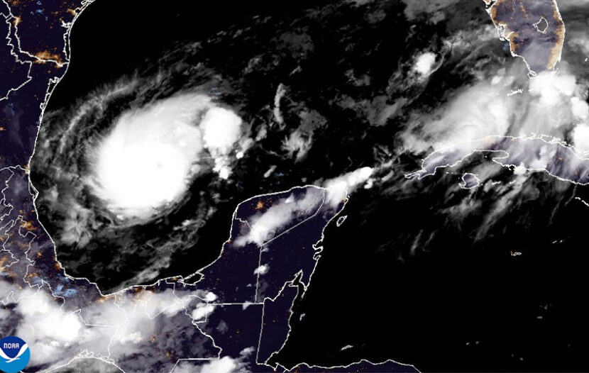
MILTON’S PATH
Milton’s centre was about 265 kilometres west-northwest of Progreso, Mexico, and about 1,195 kilometres west-southwest of Tampa early Monday, with maximum sustained winds of 205 kph and moving east-southeast at 13 kph, according to the National Hurricane Center in Miami.
Milton is a bit atypical since it formed so far west and is expected to cross the entire southern Gulf, according to Daniel Brown, a hurricane specialist at the centre.
“It’s not uncommon to get a hurricane threat in October along the west coast of Florida, but forming all the way in the southwest Gulf and then striking Florida is a little bit more unusual,” Brown said. Most storms that form in October and hit Florida come from the Caribbean, not the southwestern Gulf, he said.
A hurricane warning was in effect for Mexico from Celestun to Rio Lagartos. A hurricane watch was in effect for Mexico from Rio Lagartos to Cabo Catoche and Campeche to south of Celestun, and for Florida’s Gulf Coast from Chokoloskee to the mouth of the Suwanee River, including Tampa Bay, and for Dry Tortugas.
Forecasters warned of an 8- to 12-foot storm surge in Tampa Bay. A storm surge watch was in effect for Florida’s Gulf Coast from Flamingo northward to the mouth of the Suwannee River, including Charlotte Harbor and Tampa Bay. A tropical storm warning was issued in Mexico from Rio Lagartos to Cancun and from Campeche to south of Celestun.
A tropical storm watch was in effect for Florida’s Gulf coast from Flamingo to south of Chokoloskee and from north of the mouth of the Suwanee River to Indian Pass, and for the Florida Keys, including Florida Bay.
Florida Gov. Ron DeSantis said Sunday that while it remains to be seen where Milton will strike, it’s clear the state is going to be hit hard.
“You have time to prepare – all day today, all day Monday, probably all day Tuesday to be sure your hurricane preparedness plan is in place,” DeSantis said. “If you’re on that west coast of Florida, barrier islands, just assume you’ll be asked to leave.”
The Tampa Bay area is still cleaning up extensive damage from Helene and its powerful surge. Twelve people perished as Helene swamped the coast, with the worst damage along the narrow, 32-kilometre string of barrier islands that stretch from St. Petersburg to Clearwater.
When Milton achieved hurricane status, it marked the first time there have been three hurricanes swirling simultaneously in the Atlantic, said Colorado State University hurricane scientist Phil Klotzbach. Hurricanes Leslie and Kirk were far out at sea and not immediately threatening land.
RESOURCE SITES
VISIT FLORIDA also posted more than half a dozen resources ahead of the storm…
. Visit FloridaDisaster.org for the latest on the state’s response actions.
. Follow FLSERT on Twitter for real-time updates from the State’s Emergency Response Team.
. Florida 511 has the latest information on traffic conditions.
. Go to Alert Florida to sign up for emergency alerts and other public safety notifications.
. Check The National Hurricane Center for the latest information on any storms.
. The Expedia Emergency Accommodations Portal
. The Priceline Emergency Accommodations Portal
. Florida Attractions Association – Attractions Status Page
. Florida State Parks – Current Park Closures
With file from The Canadian Press